Document

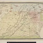
Pocket Map, showing the probable Theatre of the War. Compiled by G.A. Aschbach
Pocket Map, showing the probable Theatre of the War. Compiled by G.A. Aschbach. Published in Philadelphia, Pocket Map Showing the Probable Theatre of the War, complied by G.A. Aschbach, details the states of Virginia, Maryland and Pennsylvania. Published in 1860, before any major fighting had occurred, this map highlights areas that would see the bulk of fighting in the conflict. The map shows the balance on military power on either side by pointing out camps and forts. The Union held military bases are underlined in red, while Confederate holdings are in blue. The map also shows railway lines running across the states.
The British Library1860

