Document

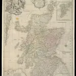
A New and Correct Mercator Map of Northern Britain [or Scotland]
During the Jacobite Rising, the English forces, led by George II’s son, William, Duke of Cumberland pursued Bonnie Prince Charlie's army back across the Scottish border. They arrived at Edinburgh at the end of January 1746, and then ventured north to Aberdeen. The Jacobites fled further north, but Cumberland was in no mood to hurry after them. He was acutely aware of the difficulty of moving troops through the Highland terrain, where roads were few and opportunities for ambush many. The most up-to-date map of Scotland available to both the English and the Jacobite sides was this map by John Elphinstone, a military engineer who served with the Duke of Cumberland's army. Though it was drawn in 1745, and was a great improvement on earlier maps, it nonetheless attracted criticism for its inaccuracies. Elphinstone's depiction of hills, for example, is entirely schematic with none of the detail necessary to thread a route between Highland glens or plan military offensives. Cumberland realised his lack of local topographical knowledge would put the English at a serious disadvantage. He spent the next two months acquiring what information he could about the lie of the land and training his troops for the particular type of campaign they would be forced to fight. Elphinstone's map was engraved by Thomas Kitchen, who worked in London's Holborn, and published by Andrew Millar in the Strand. Copies of the map were sold for 1s 6d. This one has been coloured by hand to indicate the territories of the Highland clans.
The British LibraryElphinstone, John
1745

