Project
Community
News
My App
My maps
Maps of Penicuik
Advanced search
All
Private
Favorites
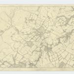
Edinburghshire, Sheet 12 - OS 6 Inch map
1852|Ordnance Survey
1:10 560
Peebles-shire, Sheet III - OS 6 Inch map
1856|Ordnance Survey
1:10 560
Edinburgh Shire 4 S.
1832|Thomson, John
1:43 000
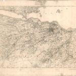
Edinburgh environs.
1838|Society for the Diffusion of Useful Knowledge (Great Britain)
1:85 000
[Edinburgh] - OS One-Inch map
1851|Ordnance Survey
1:63 360
Composite: Edinburgh Shire S.
1832|Thomson, John
1:43 000
Composite: Edinburgh Shire.
1832|Thomson, John
1:43 000
1600
1650
1700
1750
1800
1850
1900
1950
2000
History
Old maps of Penicuik
Discover the past of Penicuik on historical maps
Old maps of Penicuik
Discover the past of Penicuik on historical maps
Explore Maps
Discover History
Parent places
Edinburgh
Related places
© MapTiler
© OpenStreetMap